Sticking with the training and a scheduled long run. Problem was I didn’t really know where to run that day. Heard rumors that the weather was going to be nice so I got out the cooler for a post-picnic at some beach. Realized I had a great time in the Marin Headlands, so I printed out a map of the trail system there and plotted a course. I wanted to start at the Miwok Livery and head to Muir Beach and back up ridge trails named for mid sized carnivores, but as it turns out I couldn’t drive to the stables. The road ends at Rodeo Beach and its all trails from there.
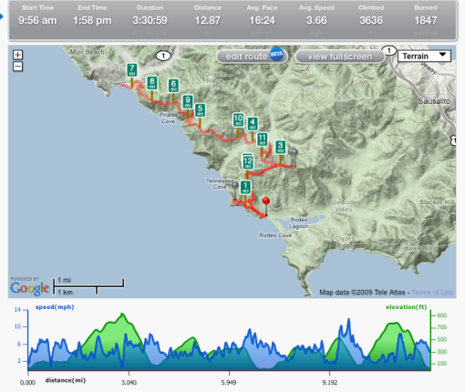
Fortunately trail heads are clearly marked, so I walked up to the barricade at the road closure and looked at the marker that read Muir Beach is 5.5 miles north on the Coastal Trail. An 11 mile out and back. Perfect. I went over to the posted map to get an idea of the landmarks and trail junctions to expect so I could stay on course. Was quite cool, and chilly in the morning at the beach around 9:30. Fog, mild breeze with chill condensation. Misty visibility of about 100 meters.
Rodeo Beach is a surf spot, and I never bothered going down here because its not known as a nude beach, but the surf was up that day and the parking lots were full. So many hot surfers going out or coming back in skin tight black neoprene daintily walking barefoot to cross the scarred asphalt roadway of Fort Cronkhite, long or short boards carried under arm. Or in the ocean, floating in the line up, paddling back to it or riding a choppy wave. Bathrooms, changing rooms with maybe a shower? I didn’t go to investigate. I shot pictures of the surf and got myself warmed up and mentally prepared to scout this new trail.
Starting at Rodeo Beach, the Coastal Trail gradually ascends about 200 feet the first mile and passes Battery Townsley. There is a side trail which takes one down to a series of batteries that are beautifully camoflauged in lichen and ice plant. There is a promontory out in the ocean and is positioned in such a way that it creates a whirlpool in the water, a compelling frothy vortex. The trail that leads past these bunkers is a scenic vista that doesn’t continue on so I looped back to the main trail and continued up an asphalt road Past Battery Townsley, up a series of stairs cut out of the local serpentine and at mile 3 came to a convergence of trailheads at an elevation of 900 feet.
At this juncture The Miwok Trail runs west downhill to Tennessee Cove and the easterly downhill trail is Wolf Ridge. The Coastal Trail’s broken asphalt road continues upwards at .08 miles to Hill 88. It was to short of a jaunt to miss out on, so I continued up hill and came to a rusted, open chain link gate, beyond which were the ruins of a helicopter landing pad, barracks and an air control station. I could see Sutro Tower across the strait, a distant ship on a sea of fog and thought to myself that days before I was looking at it from the summit of San Bruno mountain and how these mountains have become my stomping grounds. I went to go investigate the abandoned buildings and found that this spot is a haven for taggers and the graffiti in the ruins are top notch; an unexpected street gallery. I spent some time taking pictures of the art there, impressed by the quality and the content. I found that this spot was an outdoor echo chamber and had some fun beatboxing a little bit, but couldn’t get my phone to record the delay.
It was time to continue downhill, Miwok trail to Tennessee Valley. Looking down, oh boy, I knew I was going to regret having to climb back up, but a trail is a trail. One mile of a roughly 900 foot descent to Tennessee Valley, where the Miwok Livery is and also Tennessee Cove, then back up the Coastal Trail climbing about 500 feet then dipping down into some old school coastal single track at Pirates Cove. Another huge ascent and then dropping down to Muir Beach where I ran to the end just to do so.
Coming back was going to kick my ass, I knew that. I was also worried about running out of time, but I figured that if I just kept moving I could do it. I had a massage scheduled at 3. I had to walk up the steep ascents and ran out of water in my hydration unit on the way back between miles 10 and 11. I was thinking to myself that I’d never have to run that trail again, but really I keep thinking I want to. It took me over 3 and a half hours to get the job done, but as far as this routine with the long runs I will definitely be back to challenge myself on this awesome hill course.